Starlink is removing GPS from the local API on 20 May 2026. If you’re looking for a replacement, we’ve compared four USB GPS receivers across a range of prices and chipsets, tested them alongside the Starlink Mini’s built-in GPS, and found some results worth sharing.
Why we tested
In the previous post we covered the multi-source GPS support we shipped in our Nexus Telemetry application. Part of that work involved testing USB GPS receivers to make sure our NMEA parsing handled the real-world differences between devices: different chipsets, different baud rates, different constellation support, and different NMEA sentence prefixes.
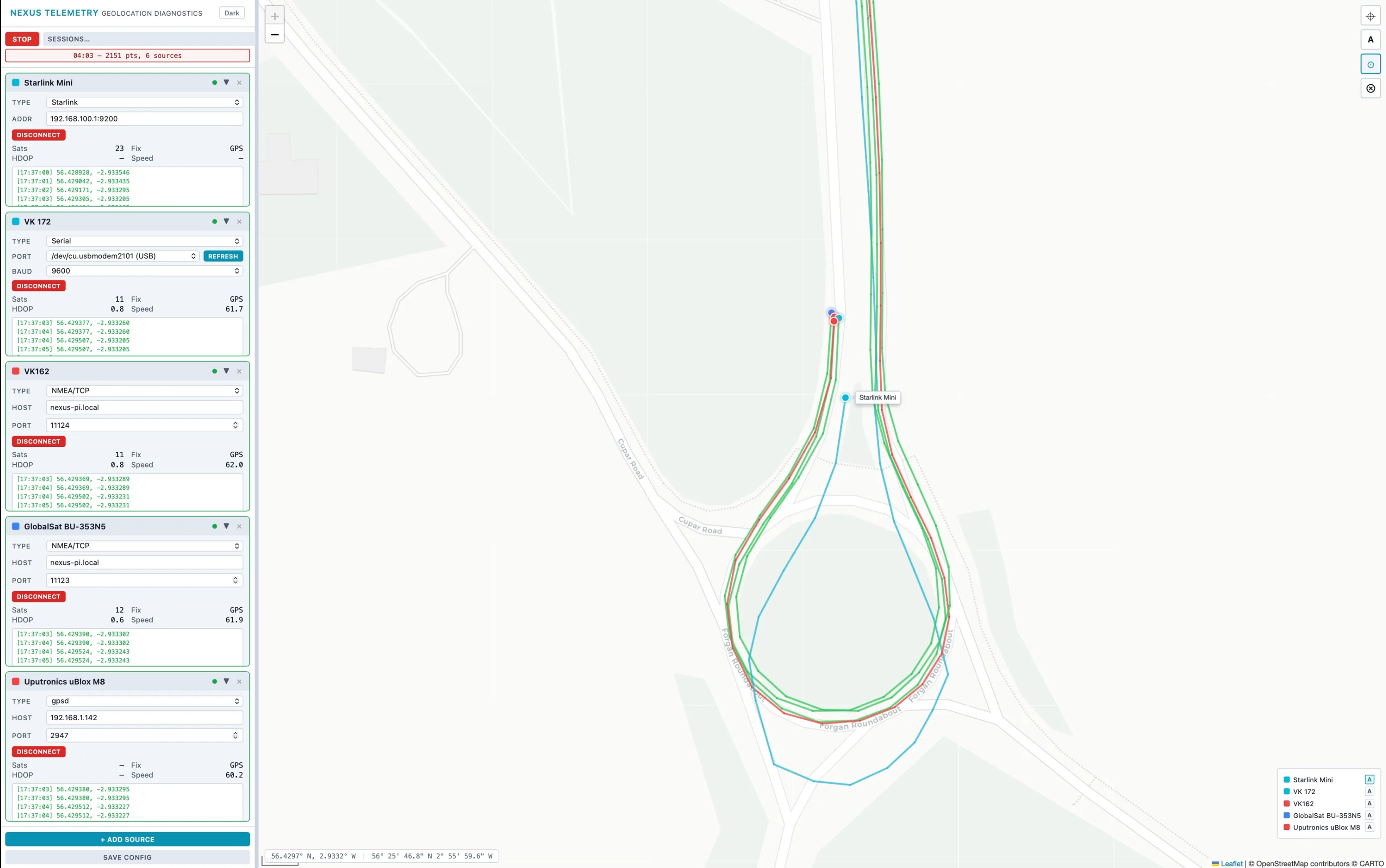
We built a dedicated test harness app to run all four receivers simultaneously alongside the Starlink Mini’s built-in GPS. This let us compare traces, satellite counts, and positioning behaviour on the same route at the same time.
Nexus Telemetry supports any NMEA-compatible receiver, from budget USB dongles to professional marine and survey equipment. The protocol is standard. If your receiver outputs NMEA 0183 or connects via gpsd, it works. For this comparison we tested four receivers in the £8 to £80 range, as these are the kind of devices Starlink users are likely to consider when replacing the built-in GPS.
The devices
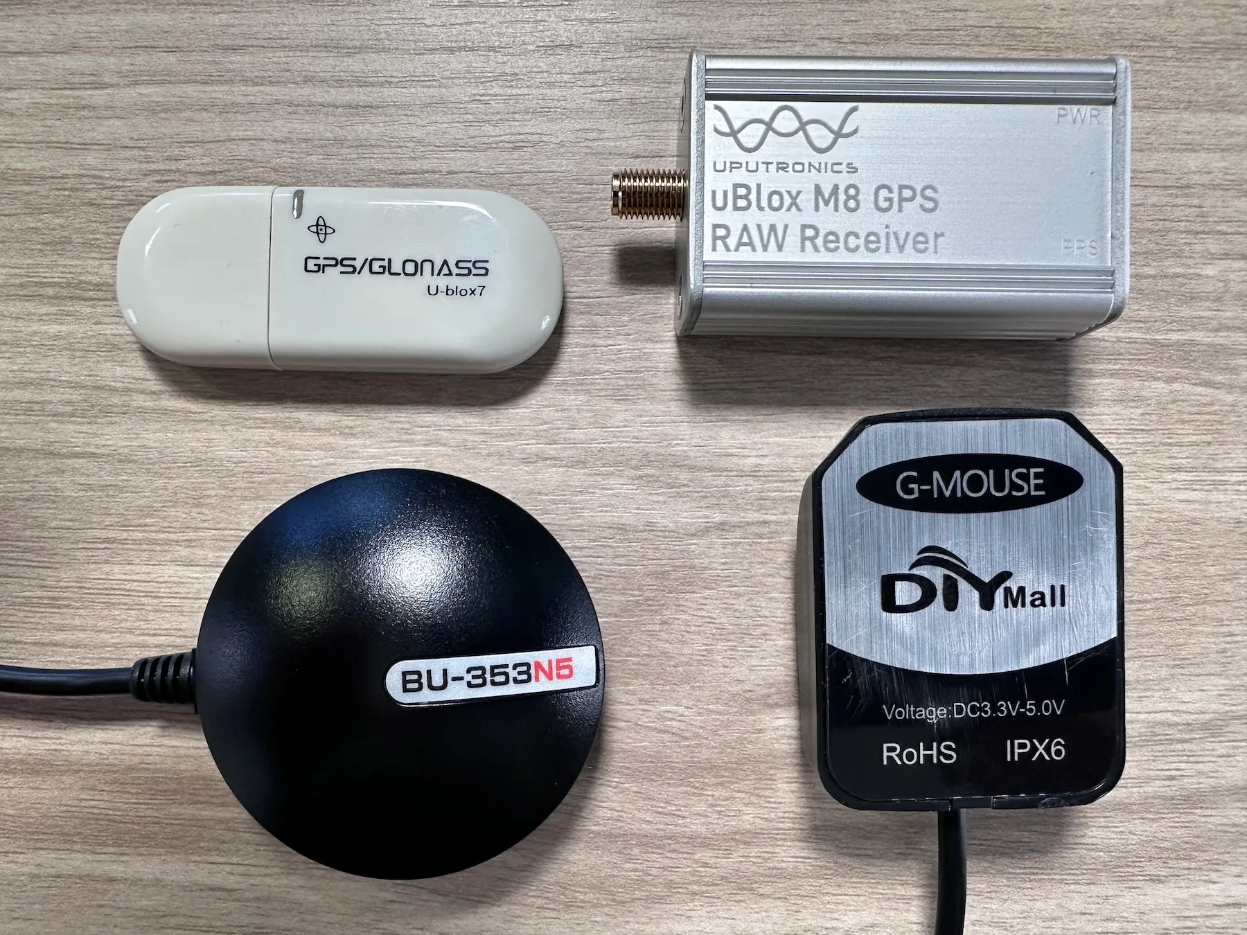
Hailege VK172 (~£8)
The cheapest option we tested. A u-blox 7 chipset in a tiny USB stick form factor that plugs directly into your laptop, no cable, no external mounting. GPS and GLONASS only, no Galileo or BeiDou. Outputs $GP prefixed sentences at 9600 baud. Indoor use only.
Stemedu VK-162 (~£12)
A step up from the VK172 but based on the same u-blox 7 generation (UBX-G7020-KT) chipset. GPS and GLONASS. Slightly larger than the VK172 with a small ceramic patch antenna and a 2m cable. Outputs $GN multi-constellation sentences at 9600 baud. Popular with Raspberry Pi and Stratux users. IPX6 rated and magnetic base.
GlobalSat BU-353N5 (~£45)
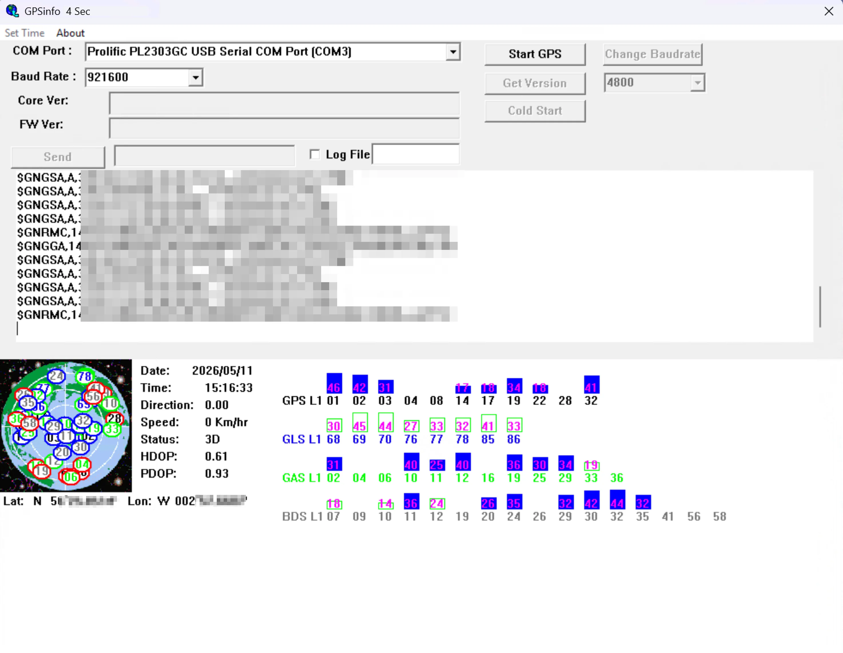
A puck-style receiver with a magnetic base, built around an Airoha AG3335MN chipset (MediaTek subsidiary). Out of the box it ships at 4800 baud and only outputs GPS sentences. There isn’t enough bandwidth at that rate for multi-constellation data. Bump the baud rate to 921600 using GlobalSat’s GpsInfo utility and it unlocks GPS, GLONASS, Galileo, BeiDou, and QZSS. We tested it at 921600 with all constellations active, which also made it a good test of our baud rate handling.
 Comes with a USB cable (152 cm) and a sealed puck housing with a magnetic base designed for vehicle mounting. Resellers describe it as water-resistant or waterproof, though the manufacturer’s own manual includes a standard warning against rain and moisture exposure. We used it in all weather without issues, but it’s worth being aware of the discrepancy if you’re planning a permanent external mount.
Uputronics uBlox M8 with active antenna (~£80)
The most capable setup we tested. A uBlox M8 USB dongle paired with a 3m active GPS patch antenna (EAD GPS560) with SMA connector. The dongle stays inside, connected to your computer. The external active antenna mounts outside with a magnetic base and a clear sky view. It’s designed for vehicle roof, boat, or metal surface mounting and is built to handle the elements. Where the other three receivers rely on small internal or ceramic patch antennas, this setup has a dedicated antenna purpose-built for GNSS reception. Professional marine and field installations would typically use higher-end receivers, but they communicate on the same NMEA protocol, so the compatibility testing applies equally.
The test
We built a custom app as a test harness to run all four USB receivers simultaneously alongside the Starlink Mini’s built-in GPS, logging and comparing traces in real time.
We tested across several hundred miles of driving in varied conditions: motorway, dual carriageway, A-roads, B-roads, and village streets. The routes included open rural stretches with clear sky views, built-up urban areas, tree-lined roads, and frequent direction changes through corners and roundabouts. We tested in both wet and dry conditions.
For direct serial testing, the receivers were connected to a MacBook running the test harness, logging NMEA sentences from each device in parallel. For TCP, UDP and gpsd testing, we mounted the receivers on the vehicle roof and connected them to a Raspberry Pi on a custom breadboard in the back of the car, forwarding NMEA over the local network to Nexus Telemetry. This let us validate both connection methods under real-world conditions. The Starlink Mini was running on the same vehicle with its GPS recorded via the gRPC endpoint (still active at the time of testing).
Each receiver’s trace was logged with timestamps, coordinates, altitude, satellite count, fix quality, and HDOP. The Starlink GPS data was recorded at the same intervals from the dish’s telemetry.
Results
Satellite counts
This is where the price difference shows most clearly.
| Device | Typical satellites | Constellations |
|---|---|---|
| VK172 | 8-12 | GPS, GLONASS |
| VK-162 | 9-13 | GPS, GLONASS |
| BU-353N5 | 10-18 | GPS, GLONASS, Galileo, BeiDou, QZSS |
| Uputronics M8 + active antenna | 18-24 | GPS, GLONASS, Galileo, BeiDou |
| Starlink Mini (built-in) | 8-28 | GPS, Galileo, GLONASS, BeiDou, QZSS (hardware) |
The Starlink Mini consistently tracked the most satellites of any source we tested. The dish uses an ST Teseo multi-constellation GNSS receiver capable of GPS, Galileo, GLONASS, BeiDou, and QZSS. SpaceX hasn’t publicly documented which constellations are enabled in firmware, but the satellite counts we observed make it clear the dish is using more than GPS alone. The Uputronics with the active antenna was close behind. The BU-353N5 performed well at its price point. The budget dongles tracked fewer satellites but still maintained a reliable fix throughout our testing.
Trace accuracy on straight roads
On motorway and dual carriageway sections, all five sources produced clean, tight traces that followed the road accurately. The differences were minimal. Even the £8 VK172 held a consistent line on a straight road. The Starlink Mini’s trace was equally clean on these sections.
If you’re using Starlink on a fixed installation or primarily travelling on main roads, any of these receivers should serve you well. Including the built-in GPS while it lasts.
The Starlink Mini loses precision on direction changes
On corners, roundabouts, and direction changes, the Starlink Mini’s GPS trace drifted. The trace would swing wide of the actual road, sometimes into adjacent fields or buildings, before converging back to the road on the next straight section. The drift was consistent and repeatable across multiple corners on the route.
 A custom test harness app we built specifically for GPS comparison testing.
The USB receivers did not show this behaviour. Even the £8 VK172 held tighter lines through corners. The BU-353N5 and the Uputronics M8 were rock solid through every direction change.
To be clear, this is an observation from our testing, not a warning. For the vast majority of use cases, this drift is likely to be negligible. Route logging, weather lookups, satellite tracking, general position awareness: the Starlink GPS handles all of these well. The drift is brief, the trace converges back quickly, and unless you’re comparing traces side by side as we were, you’d probably never notice it.
But it is a measurable difference. Where the dedicated receivers held a consistent, line-accurate trace through every corner, the Starlink GPS showed a repeatable pattern of drifting wide and correcting. If you need consistent precision in all conditions, a dedicated GPS receiver is going to give you that.
Why does this happen?
We’re not GPS engineers, so what follows is our best understanding based on what we observed and what others have researched.
The Starlink dish is mounted flat (or near-flat) on a vehicle roof. Its GPS receiver is integrated into the dish hardware, but the antenna is not optimised for positioning. As Oleg Kutkov has documented in detail, the square Starlink terminals (rev3 onwards) use a compact ceramic chip antenna with roughly 3 dB gain and an omnidirectional radiation pattern. It’s linearly polarised, while GNSS signals are circularly polarised, meaning it loses some useful signal. The dish’s primary job is phased-array beam steering to track Starlink satellites, not GPS navigation. The GPS is there to tell the dish roughly where it is so it can calculate which satellites to target.
Zhao et al. at the University of Victoria and University of Minnesota have shown that the dish’s orientation and alignment data becomes less accurate when the terminal is in a near-flat mounting position during motion, particularly when the tilt angle drops below 15°. Their research on Starlink network performance under vehicular mobility demonstrated that the boresight azimuth reported by the dish degrades significantly in these conditions1. While their paper focuses on satellite identification and network performance rather than GPS positioning, the underlying issue, that the dish struggles to accurately determine its own orientation when mounted near-flat on a moving vehicle, is relevant to understanding why the GPS trace may drift on direction changes. The dish GPS is doing exactly what it was designed to do, it just wasn’t built for the same purpose as a dedicated GPS receiver.
What we’d suggest
These are just our thoughts based on the testing we did. Your setup and needs may differ.
For fixed installations using the Nexus Telemetry Application: If your dish doesn’t move, you don’t need a GPS receiver. Just set your coordinates once in the application and you’re done.
For casual mobile use (RV, camping, travel): The £12 VK-162 is the sweet spot for most people. It’s IPX6 rated with a magnetic base and a 2m cable, so it can be mounted externally on a roof or metal surface with a clear sky view. Good accuracy at a low price.
For regular mobile use (frequent driving, route recording): The GlobalSat BU-353N5 at £45 offered the best balance of accuracy, satellite count, and convenience in our testing. The magnetic base mounts on the dashboard or roof and the multi-constellation support means faster fixes. We used it in all weather conditions without problems.
For marine, field research, or professional deployments: The Uputronics uBlox M8 with an active antenna performed best in our tests. The antenna is designed for external mounting and can handle the elements, while the dongle stays inside. Professional installations will likely use their own GNSS equipment. Nexus Telemetry supports any NMEA-compatible receiver via serial, TCP, UDP, or gpsd.
Summary
| Device | Price | Best for | Our experience |
|---|---|---|---|
| VK172 | ~£8 | Budget, occasional use | Works, but limited satellites |
| VK-162 | ~£12 | General use, Raspberry Pi | Good accuracy at a low price |
| BU-353N5 | ~£45 | Regular mobile, RV | Best balance of price and performance |
| Uputronics M8 + antenna | ~£80 | Marine, professional, field | Best accuracy and satellite count |
| Starlink Mini GPS | Built-in | General position awareness | High satellite count, but drifts on directional changes |
The Starlink GPS served its purpose well as a convenient, built-in location source. For most users it was good enough and its removal is an inconvenience. For anyone needing consistent, line-accurate precision in all conditions, a dedicated receiver has always been the better choice, and that was true before SpaceX announced the change.
For some users, though, the loss is more than an inconvenience. As PCMag reported, maritime operators in regions affected by GPS jamming and spoofing have been using the Starlink dish’s GPS as an independent cross-reference against their primary navigation systems. If the ship’s nav GPS and the dish disagreed on position, that was a strong indicator of spoofing. The reasoning from these operators is that the dish’s GPS is tightly coupled with its phased-array beam steering, making it difficult to spoof both simultaneously. Removing local access to those coordinates takes away that independent check. The enterprise API’s coarse H3 cell locations are no substitute for a precise lat/long comparison. For operators in the Black Sea, Red Sea, or Eastern Mediterranean where GPS spoofing is a real and ongoing threat, this is a meaningful capability to lose.
We’ve been following this story with PCMag since SpaceX announced the change. It’s a good reminder that the same endpoint served very different purposes for different users, and that the impact of removing it isn’t uniform.
If you’re running Nexus Telemetry, update to the latest release and configure your preferred GPS source before 20 May 2026. If you’re not running Nexus Telemetry yet, you can try it with a free trial at nexustelemetry.com.
Nexus Telemetry is built by Liquidbinary Ltd. Follow @nexustelemetry on X or subscribe to the newsletter for new posts.
Zhao, J., Baude, J., Ahangarpour, A., Devulapalli, V.K., Divakarla, S.G.L., Zhang, Z-L., Pan, J. “Demystifying Starlink Network Performance under Vehicular Mobility with Dynamic Beam Switching.” arXiv:2601.13790, January 2026. https://arxiv.org/abs/2601.13790
↩ return to article